LiDAR on the Farm: A Practical Tool for Better Grazing Management
Across the Southeast, I spend a lot of time working with producers seeking practical ways to improve grazing efficiency, protect natural resources, and make better use of every acre. One of the most promising tools I’ve seen gaining traction is LiDAR. While it has been around for years in forestry, it is now becoming more relevant and accessible for livestock producers. Initially, I had planned just to write about LiDAR, but quickly realized I would be doing the reader a disservice without expanding on the topic a bit.
Understanding LiDAR in a Grazing Context
LiDAR (Light Detection and Ranging) is a remote sensing technology that uses laser pulses to measure distance and create highly accurate, 3D maps of the land. These sensors are typically mounted on aircraft or drones and emit thousands of pulses per second. When those pulses return, they provide precise information about elevation, slope, and surface features (I jokingly say that it can see a gnat on a log). What makes LiDAR particularly interesting is its ability to capture ground elevation even through vegetation. In a region like ours, where pastures often include brush, trees, or mixed-use systems, that capability provides a clearer picture of what is actually happening on the ground. This capability is especially beneficial in the Southeast.
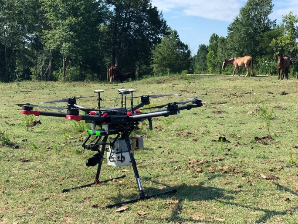
SURVEYOR MINIV3 Riegl - LIDAR USA - UAV DRONE 3D LIDAR MOBILE MODELING MAPPING GIS EXPERTS
What This Means for Producers
From a grazing management standpoint, LiDAR enables us to move toward data-driven decision-making and to stop relying solely on our observations. One of the first applications is understanding elevation and slope. Anyone who has ever spent time surveying land understands how time-consuming it can be and quickly comes to realize that your eye will fool you (ask me about this sometime… I have some great stories involving horses and skunks).
With accurate terrain data, producers can better plan layouts, fence placement, and livestock movement. Steep or erosion-prone areas can be identified early and managed appropriately. Water management is another major benefit. LiDAR helps map how water flows across a landscape, making it easier to locate wet spots, drainage, and areas at risk of erosion. This is especially important when designing watering systems or protecting sensitive areas such as streams and riparian areas.
I also see value in infrastructure planning. Whether installing cross fencing, developing heavy-use areas, or evaluating virtual fencing opportunities, having a clear understanding of the terrain reduces guesswork and improves long-term outcomes.
Lessons from Forestry and Their Role in Grazing
LiDAR has long been a useful tool in forestry for measuring tree height, canopy density, and biomass. Those same principles translate directly into grazing systems, particularly in a silvopasture setting. In the Southeast, where heat and humidity are constant challenges, understanding shade distribution can directly impact livestock performance. LiDAR allows us to evaluate canopy structure and make better decisions around tree spacing and forage production, particularly in silvopasture settings.
Accessing LiDAR Data at No Cost
One of the most encouraging aspects of this technology is that producers do not necessarily need to invest in expensive equipment to benefit from it. The USGS Lidar Explorer Map provides free access to high-resolution LiDAR datasets across the United States. Your mileage may vary based on what is available in your area. These datasets can be used with common mapping tools to evaluate elevation, slope, and water flow on your operation. Many state GIS systems also offer additional layers that can complement this data and provide even more information.
LiDAR and Photogrammetry: Using the Right Tool
Another tool in the ever-growing toolbox is photogrammetry. This method uses overlapping drone images to create maps and surface models. While both LiDAR and photogrammetry are valuable, they serve different purposes. LiDAR excels at capturing terrain data, even beneath vegetation. Photogrammetry provides high-quality visual imagery but is limited to what the camera can see. From a cost standpoint, photogrammetry is often more readily accessible and easier to implement on a day-to-day basis. For most operations, the best approach is to use free LiDAR data (if available in your area) and supplement it with drone imagery for ongoing monitoring. There are several different programs available that allow you to pull this data in and even pre-program your drone's flight plan. I was introduced to Drone Deploy about a year ago and was quickly impressed by how well it worked in less-than-ideal conditions.
Incorporating NDVI into Grazing Decisions
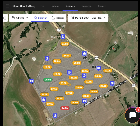
In addition to understanding the land itself, we also need to understand how it is performing. That is where NDVI (Normalized Difference Vegetation Index) becomes valuable. NDVI uses satellite or drone imagery to measure plant health by analyzing how vegetation reflects light. Healthy, actively growing forage shows higher values, while stressed or overgrazed areas show lower values. For producers, this means the ability to monitor forage growth, evaluate recovery after grazing, and identify problem areas earlier. When used alongside LiDAR data, it provides both the land's physical layout and the overall performance of the forage.
Moving Toward Smarter Grazing Systems
LiDAR shows us the shape of the land. Photogrammetry shows us what it looks like. NDVI shows us how it is performing.
Together, these 3 tools provide us with insights and opportunities for more precise, informed grazing management. As an organization, the National Grazing Lands Coalition is focused on helping producers adopt practical, science-based approaches that improve both productivity and conservation outcomes. I have had the distinct opportunity to work alongside others using this technology and immediately saw the benefit not only for forestry-related practices but also for a grazing context.
These technologies are no longer out of reach. They are available today, and they offer real opportunities to make better decisions on the ground. The producers who take advantage of them will be better positioned to manage risk, improve efficiency, and build more resilient grazing systems for the future. So, grab those datasets, delve into photogrammetry, and maybe even dip a toe into the world of NDVI.